
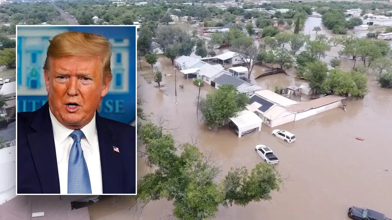
One of the nation’s deadliest flash floods in years struck one of Texas’ prime holiday recreation areas, the Guadeloupe River, early on Friday, July 4. A wall of water swept away vehicles and campers and cascaded through packed campgrounds in the hours near sunrise on Friday, producing heart-wrenching tragedy. As of noon CDT Saturday, at least 27 deaths were confirmed, including 9 children, the Associated Press reported. Many others remained missing, including 27 people from Camp Mystic, a summer camp with nearly a century of operations along and near the Guadeloupe River.
The floods were fueled by torrential rains from a thunderstorm complex that developed overnight near and west of the hardest-hit areas, across western parts of the Texas Hill Country. The region is notorious for devastating flash floods, as tropical moisture can easily surge from the Gulf of Mexico across the rugged topography. The Hill Country is just west of the Austin and San Antonio metro areas.
Remnant moisture from Tropical Storm Barry, which had moved onto the northeast coast of Mexico as a tropical depression on Sunday, drifted northward into southwest Texas over several days. The weak remnant circulation continued to pull ample low-level moisture from the western Gulf of Mexico onshore into southern Texas. By Thursday night, this appears to have been overlaid by ample higher-level moisture from the Eastern Pacific. The balloon-borne radiosonde sounding launched from Del Rio, TX, at 7 a.m. CDT Friday showed that the amount of moisture in the atmosphere (precipitable water) was the fourth highest on record across more than 70 years of twice-daily soundings.
Many studies have confirmed that human-caused climate change is making the heaviest short-term rainfall events more intense, largely by warming the world’s oceans and thus sending more water vapor into the atmosphere that can fuel heavy rain events. Sea surface temperatures this week have been as much as 1°F below the 1981-2010 average for early July in the western Gulf and Caribbean, but up to 1°F above average in the central Gulf. Long-term human-caused warming made the latter up to 10 times more likely, according to the Climate Shift Index from Climate Central.
The threat of heavy overnight rain in the western Hill Country was well anticipated by the National Weather Service, even though pinpointing exactly where such intense localized storms will form hours in advance can be difficult to impossible.
- A Flood Watch was issued at 1:18 p.m. Thursday, more than 15 hours ahead of the disaster, by the National Weather Service in New Braunfels, TX, for parts of eight counties, including hard-hit Kerr County.
- A Flood Warning went into effect for parts of Bandera and Kerr counties at 1:14 a.m. Friday.
- A Flash Flood Emergency was issued for locations along the Guadeloupe River at 5:34 a.m. Friday, with the note that “Automated rain gauges indicate a large and deadly flood wave is moving down the Guadalupe River. Flash flooding is already occurring.”
- It remains unclear whether or how the overnight warnings made it to the people most at risk – a classic “last-mile problem.”
Radar-indicated rainfall amounts in the heart of the storms were on the order of ten inches, which is on par with generation-scale 24-hour rainfall events in the Hill Country. (For instance, the town of Kerrville, near the worst flood damage, received 11.60 inches on August 2, 1978.) However, the heaviest rains in this case fell within just a few hours. Moreover, the storms appear to have been almost ideally situated to send destructive flood crests down the north and south forks of the Guadeloupe River, which converge at the town of Hunt. Camp Mystic Guadeloupe River is located on the south fork of the Guadeloupe, just upstream of that convergence point.
The Friday-morning storms left behind a weak but well-defined circulation at upper levels, known as a mesoscale convective vortex, or MCVs. Such vortexes can persist and trigger additional storms the next night, and that’s exactly what happened: widespread rains of 8-12 inches were reported northwest of Austin (roughly 50 miles north of the Friday flood disaster). Flash flood emergencies were again issued early Saturday, and at least two deaths had been confirmed by late Saturday morning, according to local authorities cited by KXAN-TV.
 Figure 1. Infrared satellite image of Tropical Storm Chantal at 1726Z (1:26 p.m. EDT) Saturday, July 5, 2025. (Image credit: NOAA Satellites)
Chantal becomes the Atlantic’s third named storm of 2025
Tropical Storm watches and warnings were flying for much of the South Carolina and North Carolina coast on Saturday as Tropical Storm Chantal crawled northward toward an expected Sunday-morning landfall. Chantal formed a few hundred miles south of the South Carolina coast at 8 a.m. EDT Saturday, July 5. Chantal’s formation date of July 5 comes almost two months before the typical August 3 appearance of the season’s third named storm (based on 1991-2020 climatology). The usual date of the Atlantic’s first hurricane is August 11. Chantal’s formation was aided by warm sea surface temperatures around 29 degrees Celsius (84°F), which is about one degree Fahrenheit above average for this time of year.
At 2 p.m. EDT Saturday, July 5, Chantal was located about 180 miles (300 km) south-southwest of Wilmington, North Carolina, with top sustained winds of 45 mph (75 km/h), a central pressure of 1006 mb, headed north at 3 mph.
Forecast for Chantal
Moderate wind shear of 10-20 knots from strong upper-level winds out of the southwest should keep Chantal from becoming very strong, as will the storm’s limited amount of time over water before landfall on Sunday morning. NHC predicts that Chantal’s winds will peak at 50 mph (80 km/h) at the time of landfall.
Chantal’s main impact will be from heavy rains of two to four inches and storm surge flooding of one to three feet, which will likely cause minor flooding in North Carolina. Dangerous rip currents will also be a threat along the Carolina coast.
An exceptionally weak one-two-three punch from the season’s first three named storms
Chantal is destined to be the season’s third-straight short lived named storm. Chantal follows on the heels of two other underachieving tropical storms: Andrea, which formed on June 24 in the remote central Atlantic between Bermuda and the Azores Islands, and Barry, which formed off the coast near Tampico, Mexico, on June 29. Andrea and Barry both lasted about 12 hours as named storms; Chantal will likely last less than 36 hours. According to hurricane scientist Michael Lowry, Andrea and Barry jointly produced an anemic 0.6 on the Accumulated Cyclone Energy or ACE scale, and “never in the modern record (since at least 1950) have the first two storms of the season produced so little activity as measured by the Accumulated Cyclone Energy or ACE.” Now that’s a record we like to see continue!
![]()
Republish our articles for free, online or in print, under a Creative Commons license.


 English (US) ·